Characteristics of the marine heatwave
SSTs soared in the Northwest European shelf (NWS) in June 2023. The National Oceanic and Atmospheric Administration (NOAA) declared a category IV MHW for parts of it on 17 June. We follow NOAA definition in this article, which is based on Hobday et al. (2018): Category IV means SSTs were greater than their average by four times their daily 90th centile deviation calculated over 1982–20121. The average over the whole NWS was +2.9 °C warmer than climatological June in the Operational Sea Surface Temperature and Sea Ice Analysis system (OSTIA15,16), based on satellite observations (Fig. 1a). Given that the 90th centile over the shelf is +1 °C, +2.9 °C corresponds to a category II MHW (twice above 90th centile anomaly) that lasted for 16 days, which is unprecedented in the last 40 years (1982-2022, Fig. 1a). The rapidity of the MHW onset was also remarkable: NWS-averaged anomalies rose from category I to category II in just 6 days (10–16 June). With a rise of 2.4 °C in 7 days, this trend is the second highest in the OSTIA 40-year record (Fig. 1d). Seasonally stratifying regions of the NWS experienced the strongest surface warming compared to shallow, tidally mixed parts of the shelf (Channel and Irish sea in Fig. 1c). During the peak week (19–26 June, SSTs locally showed +5 °C anomalies in the central North Sea and the Irish shelf, reaching category IV in a few coastal areas (Fig. 1c). The Irish shelf anomaly started earlier (end of May) than in the central North Sea (second week of June) (Fig. S1). The local peaks are confirmed by gliders, which recorded near-surface temperatures over 16 °C in the Rockall Trough (Fig. 2a) and in the western North Sea (Fig. 2e), +4 °C and +5 °C above climatology for this time of year, and +2 °C above the average peak SSTs in August for these areas. The gliders east of Orkney observed peak SSTs of 14.5–15 °C, 3.5–4 °C above OSTIA climatology (Fig. 2c). The Western Channel Observatory also provided information on the MHW in the context of its long observational record (>100 years at location E1 and 40 years at L4; Fig. 2g, h). These locations showed a category I MHW throughout June, with record high temperatures for June at L4 (17.9 °C), and temperatures near the envelope of maximum recorded temperatures for E1.
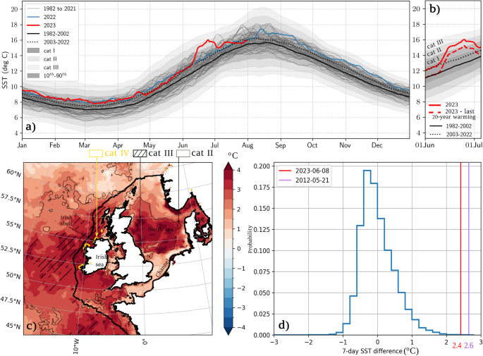
a OSTIA SSTs for 1982–2023, mean climatologies (1982–2002 in full line and 2003–2022 in dotted line), 10th–90th centiles (anomalies smoothed with 31-day moving average), Shading: Category I, Category II, Category III marine heatwaves using Hobday et al.1 averaged over the NWS (NWS=thick black contour in (c)). b Same as a, but zoomed over the MHW, dashed red line is 2023-last 20-year trend c map of average OSTIA SST anomaly during peak week (19–25 June 2023) (relative to 1982–2012 mean), thin plain black contour: category II MHW, hashes: category III MHW, yellow contour: category IV MHW. d Normalised probability distribution of 7-day SST trends on the northwest European shelf—June 2023 maximum trend is in red (2.4 °C). It is the second highest trend after purple maximum trend (2.6 °C).
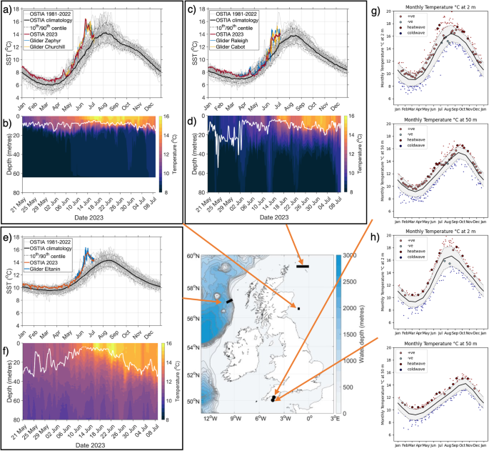
Glider observations: panel a, c, e near-surface (4 m) in-situ temperature observations, compared to closest OSTIA SST grid cells. Light grey lines show OSTIA daily SST between 1981 and 2023, heavy black line shows 1982–2010 daily mean (OSTIA) and black dashed line 10th/90th centile (OSTIA), panels b, d, f temperature profiles from gliders, white line shows SML depth. Panels g, h Monthly average temperature at 2 and 50 m depth (solid black line) for the Western Channel Observatory (WCO) time-series stations at L4 (50°15.0’N; 4°13.0’W) and E1 (50°02.6’N; 4°22.5’W) together with the 90th and 10th centile (dashed line) region shaded in grey. Data for 2023 shown in large symbols with dark red shading depicting heatwave conditions, light red a positive anomaly, light blue a negative anomaly and dark blue cold wave conditions. Small symbols outside the centile range depict record temperature on a given day of year for years other than 2023. Averaging period for E1 is 1903-2023; L4 is 1988-2023. Sampling frequency at L4 is weekly (since 1988) and bi-weekly or monthly at E1 (since 2002).
The glider observations also provide information about the depth of the anomaly (Fig. 2b, d, f). All the gliders show a shoaling of the surface mixed layer (SML) depth from the start of June, with an extremely shallow SML (below 10 m) from 10 to 20 June, which deepens to 10–20 m from 20 to 30 June. E1 shows a 15 m depth SML on 27 June, 10 m shallower than in 2022 (Fig. S5d, e) and CTD profiles in the Celtic Sea on 22–23 June also recorded 5–15 m shallow SML (Fig. S5f). In late June and July, the mixed layer depth increases (Figs. 2 and S2) and the anomalies reduce throughout the column, as also recorded for E1 and L4 at 50 m (Fig. 2g, h).
This June anomaly is additional to 2022 and early 2023 being 0.9 °C warmer than 1982–2012 climatology at the start of June across the NWS at the surface (Fig. 1b) and at depth (E1 and L4 in Fig. 2; EN4 profiles in Fig. S3b, c; and regional OCN_amm7_RAN reanalysis Fig. S4). This is consistent with the background 2003–2022 average being +0.9 °C warmer than 1982–2002 in June (Fig. 1b).
Origins of the marine heatwave
We first aim to isolate the role of ocean stratification pre-conditioning on the MHW. Most regions of the NWS experienced warmer than average temperatures throughout the water column in winter and spring 2023, prior to the June MHW development. The SML depth averaged over the NWS shows no anomalous behaviour in comparison to the past 22 years of the OCN_amm7_RAN reanalysis (Fig. S4). Seasonal stratification started in April and SML depth settled to ~20 m depth on average over the shelf around mid-May. Similarly, profiles in the Western Channel (E1, Fig. S5a, b) show a similar stratification in late May/early June of 2022 and 2033, suggesting no particularly strong or early stratification before the MHW. Further to this, the Price–Weller–Pinkel (“PWP”) one-dimensional upper ocean mixed layer model17 initialised from an EN4 profile close to where glider Eltanin (57 N 13 W) was operating and driven by ERA5 supported this finding (Fig. S2). Figure S6 (EN4 analysis) further supports the limited impact of salinity on June stratification18.
To further test this hypothesis, we applied a high resolution regional coupled model (UKC317) to test whether the MHW would have developed across the NWS given the same atmospheric forcing but initialised from different ocean states representative of conditions in preceding years (Fig. S7). Results show that all simulations consistently develop the MHW, confirming little effect of ocean pre-conditioning and advection of Atlantic waters. Ocean pre-conditioning is therefore of secondary importance compared to atmospheric forcing.
Indeed, June 2023 was the sunniest June since 1957 over the United Kingdom19. ERA5 monthly mean net shortwave radiation confirms June 2023 was unusually sunny over the NWS as a whole (Fig. S8a). Latent heat fluxes were also lower than average (Fig. S8d). June ocean wave activity was the lowest recorded over the shelf in the last 40 years according to the NWS regional wave reanalysis WAVamm15_RAN (Fig. S9a, c), linked with both local (North Sea/NWS) and remote (North Atlantic) weak winds (Fig. S9d).
Figure 3 shows six stages of the MHW evolution, using output from km-scale coupled simulations (CPL, see Methods and note Section 2 in Supplementary material shows CPL simulations are of good quality compared to observations). We use the standard weather regime classification over Northwest Europe20 to describe the weather situation (top row, Fig. 3). Stage 1 in the first week of June shows slow warming, with a high pressure system centred over the British Isles (weather regimes (WR) 25, 6, 9), very high solar radiation (over 600 W m−2) and low wind speeds (Fig. S10), which shoaled the SML by about 4 m. Stage 2 shows a warming hiatus on the 6–9 June, with a low-pressure system centred over the Azores, bringing windier conditions but also warm and moist tropical air over the NWS (Fig. S10). Stage 3 between the 10 and 17 June sees the strongest warming trend. High-pressure moved to Scandinavia (WR 5) and another low-pressure system over the mid-Atlantic maintained a weak flow of tropical air over the UK (WR 16). That week showed a combination of (i) high solar radiation with long hours of sunshine near the summer solstice (Fig. 3d); (ii) warm and moist air reducing sensible and latent heat fluxes and longwave radiative cooling (night-time cooling reduced to 50 W/m2, Fig. S3e, Fig. S10); (iii) very weak winds (Fig. S10) and; (iv) neap tides (contributed to +0.05 °C by shoaling the SML by 1 m compared to spring tides (Fig. S10)). The combination of (i), (iii) and (iv) shoaled the SML to less than 10 m and contributed to large shortwave radiative heating (SW) of the SML by +10.0 °C over phases 1–3, only partially compensated by diurnal and tidal entrainment (−2.7 °C), longwave radiative cooling (LW, −3.0 °C), and weak latent (LH) and sensible (SH) cooling (−1.6 °C, Fig. 3d). The total surface heat fluxes contribution to SST trend in stages 1–3 was enhanced by 85% by shallowing of the SML (from 2.9 °C to 5.5 °C, not shown). Figure 3d shows as an example that SW contribution would have been 5.7 °C instead of 10.0 °C if the SML had not shoaled (difference between SW term calculated with actual SML depth and SW term calculated with fixed SML depth from June 1st).
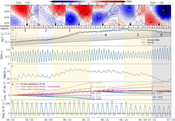
Top row: table with numbers: weather regimes based on 30 clusters using Neal et al.45, red means anticyclonic component over NWS, light blue cyclonic with weak circulation, dark blue strong cyclonic circulation. Weather regimes 9, 5, 16, 7, 2, 26 illustrated at the top (colour shading: mean sea level pressure (MSLP) anomalies (hPa) and MSLP mean values plotted in contours (2 hPa intervals)). Other rows: averages over the Northwest European Shelf (NWS) of: a Sea surface temperature (°C) from OSTIA, OSTIA 1982–2012 climatology (Ostia-clim) and the coupled simulation CPL, b sea surface height (m)—anomaly from reference geoid, the amplitude of the variations show the tidal amplitude, c surface mixed layer depth (de Boyer Montégut22 density calculation using 0.2 °C gradient and 3 m reference level) (m) d cumulative temperature trend from shortwave radiative (SW, yellow), longwave radiative (LW, blue), sensible (SH, red) and latent (LH, cyan) heat fluxes, from entrainment (deepening of the mixed layer, grey), SW + LW + SH + LH in dashed magenta and same terms+entrainment in magenta (Eq. 1 in Methods). Also added is SW calculated with SML depth from June 1st (fixed) in yellow dotted line. Black is the actual cumulative trend. Budget is reset to cumulated dT/dt at the start of phase 4 and 6. e hourly total heat flux into the ocean (SW + LW + SH + LH).
Figure 4 shows the spatial distribution of the SW, LW, LH and entrainment terms of the mixed layer heat budget (Eq. 1) cumulated over phases 1–3, as well as the SML depth at the start (June 1st) and the end (June 17th). Figure 4a shows the heterogeneity of the SML over the NWS on June 1st, with areas permanently mixed by tidal currents (Channel, Irish Sea) showing weak SST trends for all the terms. These areas keep a deep SML from the 1st to the 17th. In the rest of the domain, SML becomes shallower than 10 m on June 17th, meaning that some areas such as the Celtic Sea experienced a shallowing of the SML by about 30 m. The heat budget terms are largest in the areas where the SML was shallower from the start, mostly over the NWS and adjacent areas. The entrainment terms is also largest on the NWS and adjacent areas, where tidal energy dissipation enhances vertical mixing.
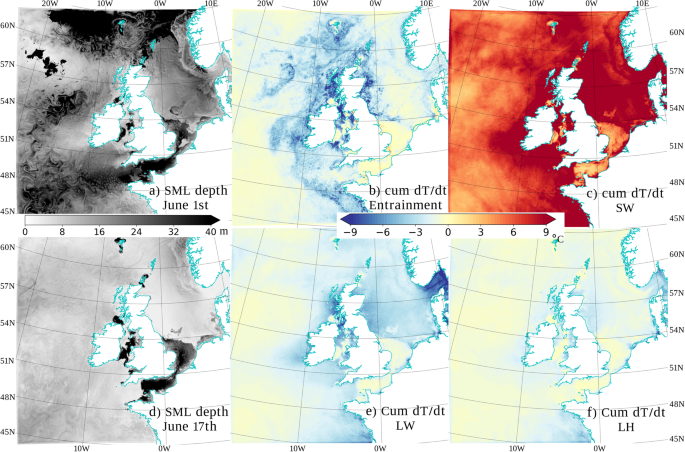
a SML depth on June 1st, d SML depth on June 17th b cumulative SST trend (1–17 June) from entrainment at the bottom of the surface mixed layer, c from shortwave radiative flux, e from longwave radiative flux, f from latent heat flux. Note sensible heat flux not shown as tendencies are negligible compared to the other terms.
During stages 4 and 5, less strong shortwave influx (Fig. S3e) still results in +6 °C tendency (Fig. Sd) because of the shallow SML (Figs. 3c and 4d) but entrainment, latent heat and longwave radiative fluxes compensate it: the MHW is stable (Fig. 3d). Indeed, stage 4 saw the high-pressure system move south of the British Isles and most of NWS experienced weakly cyclonic conditions. Winds remained weak but solar heating was reduced due to clouds associated with weakly cyclonic regimes (WR 2, 7, 11, Fig. 3e, Fig. S10). The shallow mixed layer and persistent weak winds meant the heat remained trapped near the ocean surface, although spring tides started to deepen the mixed layer (by 2 m, Fig. S11). Stage 5 saw windier conditions, cloudier skies (WR 2), the SML deepened by 5 m but neap tide prevented an extra 1.5 m deepening and 0.1 °C cooling, Figure. S11). The surface anomaly remained until the start of July, when a low-pressure centre (WR 26) swept through with high wind speeds (10 m s−1 averaged over NWS), both reducing and mixing the surface anomaly through the water column depth (Fig. 3c, d, S12). The high-pressure centre moved over central Europe in July, and unsettled weather in July and early August brought SST and whole ocean heat content closer to average (Fig. 1a, E1 & L4 in Fig. 2, Fig. S12).
Feedbacks on the weather
Under persistent anticyclonic conditions, slow-moving air accumulates heat and moisture from the sea before being advected over land21. To assess the local atmospheric response to the MHW, Fig. 5 shows the difference between two 31-day duration high resolution regional weather simulations. One uses the observed daily SST during June 2023 as a lower boundary condition (labelled ATMostia) and the other uses a climatological SST (ATMclim; shown in Fig. 3). Once the MHW is well established, its impact on the near-surface air temperature over the British Isles averages +1.1 °C during the last two weeks of June (stages 4 and 5). Figure 5c shows spatial anomalies to be especially strong in Scotland, Ireland, Wales, southwest England, Brittany and Denmark. Southeast England, northern France and the Netherlands show weaker warming because the SST anomaly in the Channel is relatively reduced (+1 °C) due to strong tidal mixing in this shallow area (Fig. 4d), which prevents a near-surface build-up of heat. During stage 4, the anomalous air temperature peaks at 16:00 UTC up to +1.5 °C on three days: 19, 21 and 23 of June (Fig. 5a). These peaks are associated with sea breezes, evident by stronger-than-usual diurnal peaks in land-average 10 m wind speeds (Fig. 5b).
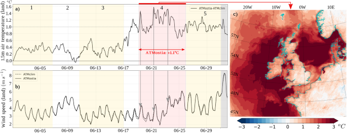
a 1.5 m air temperature difference averaged over the British Isles between a regional atmospheric simulation with the observed marine heatwave (ATMostia, with OSTIA SSTs) and without (ATMclim, with climatological OSTIA SSTs). b Wind averaged over the British Isles in both simulations (ATMostia in full line and ATMclim in dashed line). c Map of 1.5 m air–temperature differences (ATMostia–ATMclim) averaged from 19 to 25 June (red area on a, b).
Interestingly, winds are increased over land by the MHW during stage 4 (Fig. 5b), which is counter-intuitive given the land-sea contrast is reduced in the simulations with MHW (Fig. S13a). The sea breezes are driven by such a strong land-sea temperature gradient (5–10 °C) that their strength is not reduced by a −2 °C difference in the gradient (Fig. S13a). Instead, winds are increased over the ocean through a deeper boundary layer which brings more momentum near the surface (Fig. S14). This momentum increase over the sea is propagated over land by the sea breezes and reinforces them. Higher humidity air is then advected over land (7% increase, Fig. S13b) and precipitation is increased by 23% over the British Isles because of the MHW during stage 4 (Fig. S13c). Precipitation during the week of 19 June is mostly convective and associated with convergence over land. On 21 June, a sea-breeze day, the probability of rainfall in England, Wales and Ireland was generally increased by the MHW, and convective events associated with sea breeze convergence in the English southwest peninsula would likely not have happened without the build-up of high SSTs over the preceding 2 weeks (Fig. S15).
The MHW increased temperature and precipitation over land, through advection of near-surface air temperature and moisture anomalies by sea breezes. Now, we demonstrate that the MHW generated daytime positive feedback on the weather over the sea (Fig. 6). Indeed, in stage 4, cloud cover was 15% lower over the shelf (Fig. 6a) in ATMostia compared to ATMclim, linked with a higher boundary layer height with warmer SSTs (Fig. S14). This increased the shortwave radiative heat flux into the ocean by 11% during stage 4 (up to 78 W m−2, Fig. 5b). The reduced cloud cover is shown for 20 June at 15:00 UTC (Fig. 6c), with the probability of low-cloud cover exceeding 37.5% in an 18-member ensemble (ATMostia_ens) strongly reduced over the sea when compared with ATMclim_ens. Satellite data showed no low-level clouds southwest of the domain, in agreement with ATMostia (not shown). All the other heat fluxes (LW, SH, LH) tended to cool the ocean more with the MHW than without, due to raised SSTs and winds (negative feedback). However, the increased shortwave (SW) radiation by 11% counteracted the increased cooling by LW, SH and LH (Fig. 6b): the negative feedback was only 4% during stage 4, compared to 15% during stage 5. The positive SW feedback increased the temperature anomalies by 0.4 °C during phase 4 (calculated using the SML heat budget in Eq. 1, see Methods). Without this positive feedback, the SST would have stayed stable, it would not have increased by a further 0.4 °C during stage 4.
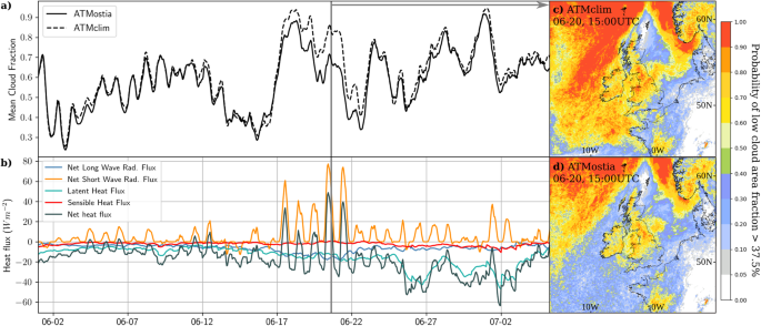
a Mean cloud fraction over sea (averaged over the whole atmospheric column and over the northwest shelf) in the regional atmospheric simulation with MHW (ATMostia in full line) and without (ATMclim in dashed line). b Difference in heat flux (positive indicates more heat flux into the ocean) between ATMostia and ATMclim: net heat flux (dark green), SH (red), LH (sea blue), LW (blue), SW (yellow). c Probability of low cloud cover fraction >37.5% for 20 June 20 at 15:00UTC (grey line in a, b) in an ensemble of regional ATMclim started on 19 June. d Same as c but with ATMostia.
Marine heatwave in a changing climate
Finally, we investigate whether the June 2023 MHW over the NWS is part of a trend and quantify its projected future frequency. Figure 7a–c shows the warm and cold sea surface anomalies for the Western Channel Observatory (WCO) stations and OSTIA averaged over the NWS. There is a clear trend towards fewer cold and more warm spells over the past 20 years for both E1 and OSTIA datasets, in agreement with a previous study for OSTIA22. All three datasets show a stronger shift in the last 8 years. Remarkably, the last 2 years have seen very few cold spells in the WCO and none for the whole NWS. This coincides with the disappearance of the northeastern Atlantic “cold blob” of 2015–202123 (Fig. S3a). The additional +0.9 °C background warming anomaly for June from the last 20 years lifted the MHW intensity up to category II instead of category I for 16 days (Fig. 1a). However, the anticyclonic weather regime period linked with the build-up of the MHW is likely coming from weather variability or potentially teleconnections with a transition from La Niña to El Niño24: no recent trend in WRs 5, 6, 9 and 16 is clearly linked with climate change25.
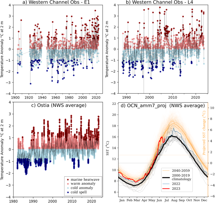
a 1903–Aug 2023 2 m depth temperature anomaly timeseries at E1, b 1988–Aug 2023 2 m depth temperature anomaly timeseries at L4 (see Fig. 2 for location). Light red circles are positive anomalies, dark red circles represent heatwave conditions (>90th centile); Light blue circles are negative anomalies, dark blue circles represent cold spell conditions (c 1982–2023 OSTIA foundation SST timeseries overaged over the NWS. d Annual cycle of SSTs averaged across the NWS: grey 2000–2019 OCN_amm7_RAN reanalysis, orange future changes from NWS PPE projections (2040–2059). Bold line is the daily average. Left axis actual value, right axis shows SST difference with present-day. Blue line is 2022, red line 2023.
To assess how this MHW compares to future projections, we make use of the NWS future projections26: a 12-member regional ocean downscaling of the Hadley Centre Perturbed Parameter Ensemble (PPE27). This NWS PPE ensemble uses a high-end Representative Concentration Pathway (RCP8.5) with a high climate sensitivity global climate model. In this global ensemble, global mean temperatures reach +1.9 °C (1.7–2.2 °C) by 2040–2059 compared to 2000–2019. The daily mean SST increase over the NWS in Fig. 7d suggests that temperatures observed during the 2023 June MHW would be considered a small warm anomaly (+0.3 °C) by 2040–2059, an average month by 2050–2069, and would be considered a cold spell by the end of the century (2079–2098) (Fig. S16). Using the Hobday MHWs analysis1 on the NWS PPE, we find a rise of the percentage of the year experiencing a MHW from 8% in 2000–2019 to 66% in 2040–2059 and finally 93% by the last 20 years of the century (Figs. S17–20, Fig. S21c, Table S1). By 2079–2098, 39% of the NWS experience MHWs more than 95% of the time (Fig. S20, Table S1). The average temperature above the 90th centile threshold (relative to 2000–2019) is +0.44 °C (2000–2019), +0.89 °C (2040–2059) and +2.11 °C (2079–2098) (Fig. S20f). We note that summer SSTs increase more than winter SSTs, making the early summer (May/June) warming trends stronger. The weather regimes (WR) associated with the build-up (phases 1–3) and stationarity (phases 4–5) of this MHW are projected to slightly increase in frequency in summer by the end of the century by about 0.25% and 0.6% respectively, while WR associated with its breakdown (phase 6) should decrease slightly (−0.35%) (Fig. S21).

