
As of Thursday afternoon, Philippe is still a tropical storm as it travels north towards Bermuda.
Philippe is expected to pass just to the west of Bermuda as a tropical storm on Friday. The storm is then forecast to become post-tropical late Saturday, as it approaches the southern marine waters of the Maritimes. By Sunday, Philippe will combine with a separate weather front producing a large fall storm that will continue into the St. Lawrence River Valley.
The post-tropical transition of Philippe will result in a large, sprawling storm system. Wind and rain will spread well out from the centre to impact all three Maritime provinces. The intensity of the wind and rain will be highly varied across the region.
Philippe forecast to become a large post-tropical storm as it moves near and through the Maritimes this weekend.
NEW BRUNSWICK
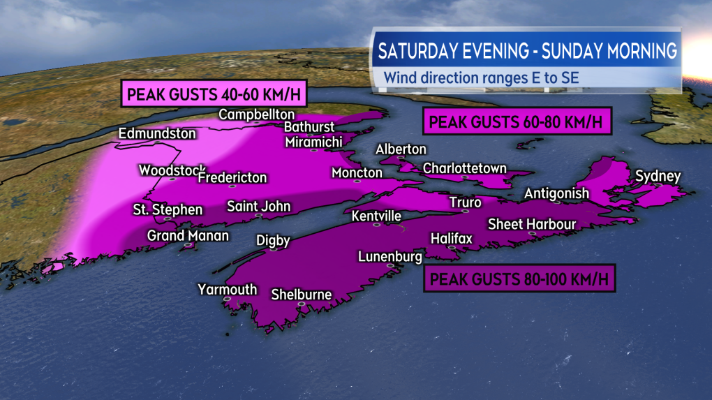
In New Brunswick, Philippe will make the most impact Saturday night through Sunday morning. An easterly wind will increase through the night to peak with gusts of 40 to 80 km/h for most of the province. Stronger gusts of 80 to 90 km/h are possible for areas on and near the Bay of Fundy coastline, as well as for the Acadian Peninsula. Wind will turn south and diminish for southern areas of the province Sunday morning. Wind will turn south and diminish for northern areas of the province Sunday afternoon. While unlikely to be widespread, there is a risk of power outages with the higher wind.
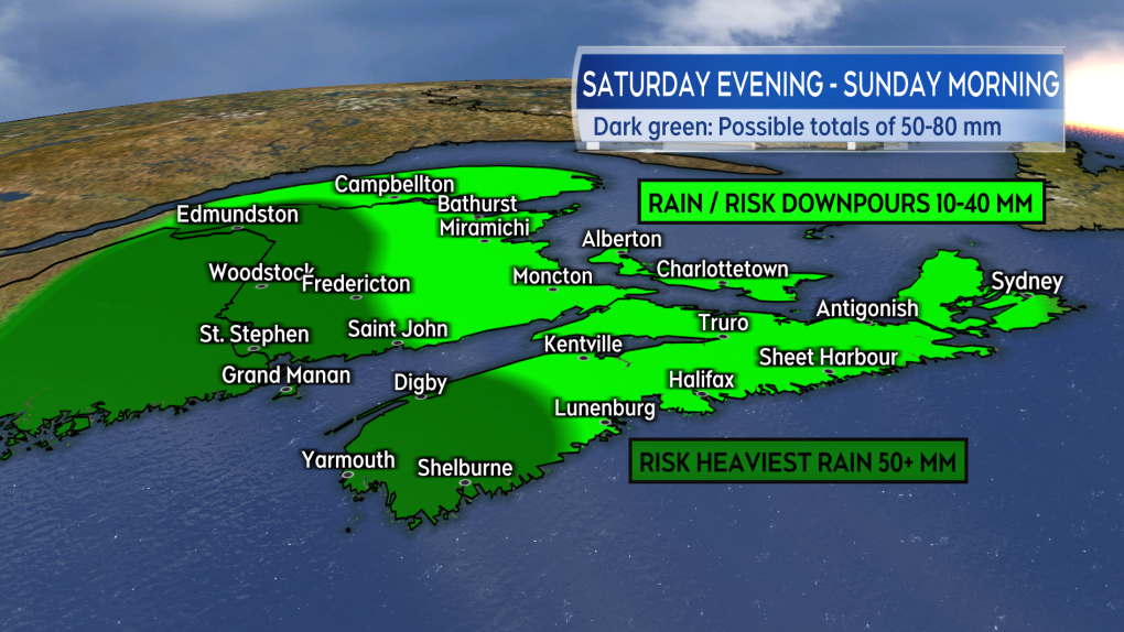
The first of the rain will reach southwestern New Brunswick by Saturday evening. Rain will be falling across much of the province near and after midnight. Rain eases in southern areas of New Brunswick through Sunday morning. Rain eases in northern areas of New Brunswick through Sunday afternoon. The heaviest rain looks most likely for western New Brunswick into Maine. The heaviest rain could total 50 to 80 mm, producing a risk of localized flooding and flash flooding.
Some increased wave action is expected on the coastlines of New Brunswick by Sunday morning. The risk of coastal flooding is very low.
A Special Weather Statement is in effect for New Brunswick by Environment Canada.
 Outlook into peak wind gusts possible in the Maritimes late Saturday through Sunday morning.
NOVA SCOTIA
The height of the inclement weather in Nova Scotia will be between Saturday evening and Sunday morning. An easterly wind becoming southeasterly will peak with gusts of 60 to 100 km/h Saturday night and Sunday morning.
The strongest of those wind gusts will most likely be on exposed areas of the Atlantic coastline, as well as northern Inverness County, due to the topography of the Highlands. Western Nova Scotia is expected to be through the highest wind by mid-Sunday morning. Eastern Nova Scotia, including Cape Breton, should be through the highest wind by or shortly after noon on Sunday. The period of high and gusty wind brings a risk of power outages.
Rain will accompany the wind Saturday night through Sunday morning. For most of the province, rain totals are expected to range 20 to 40 mm. There is a risk of rain totals reaching 50 mm or more in parts of southwestern Nova Scotia. Downpours may accompany the rain. The risk of downpours is highest for western Nova Scotia late Saturday night. The risk of downpours is highest for eastern Nova Scotia early Sunday morning.
Wave action is expected to increase on the Atlantic coastline of Nova Scotia Saturday night into Sunday morning. The waves appear to be significantly less than what Lee produced. The risk of coastal flooding is very low. Some extra caution may be warranted for parts of the coast previously damaged by Lee, as they may be more vulnerable to further erosion from the wave action.
A Special Weather Statement is in effect for Nova Scotia by Environment Canada. A further Tropical Weather Statement has been issued for western parts of the province by the Canadian Hurricane Centre.
 Outlook into potential rain for the region late Saturday through Sunday morning.
PRINCE EDWARD ISLAND AND MAGDALEN ISLANDS
Prince Edward Island and the Magdalen Islands will likely get into their strongest wind early Sunday morning through early Sunday afternoon. Southeast wind gusts could peak between 60 and 90 km/h. The strongest of those gusts will most likely be around exposed areas of the coastline, such as points and bays that are open to the east. A risk of power outages will accompany the period of high and gusty wind.
Rain isn’t expected to be much of an issue for the area. Currently it looks like a possible 10 to 20 mm. The rain should arrive early Sunday morning, then ease to a chance of showers Sunday afternoon.
Some increased wave action is expected in the Gulf of St. Lawrence on Sunday. Overall though, the risk of coastal flooding looks very low at this time.
Both Prince Edward Island and the Magdalen Islands are under a Special Weather Statement by Environment Canada.
FURTHER UPDATES
We are about 48 hours out from the first of the weather reaching the region. There is still time to see change in timing and intensity of the rain and wind. Best to check in frequently on your forecast and any alerts issued by Environment Canada as we head into the Thanksgiving weekend.
The period of higher wind could impact some travel services such as the ferries. While the leaves have started to come off the trees, they aren’t all off yet. The remaining foliage can work to amplify the effect of the wind and increase the risk of branches contacting power lines and creating an outage. Also, it would be a good idea to check to make sure drainage on properties is free from early fall debris to ensure that any heavy rain has the best chance of draining without issue.
Watch for daily updates on CTV News Atlantic programming, as well as ctvnewsatlantic.ca.