A tornado is seen near Cedar Rapids, Iowa, on Tuesday. More severe weather was forecast to move into the region, potentially bringing large hail, damaging winds and tornadoes in parts of western Iowa and eastern Nebraska, according to the National Weather Service.
Nick Rohlman/The Gazette/AP
hide caption
toggle caption
Nick Rohlman/The Gazette/AP
DES MOINES, Iowa — Tornado warnings, flash flooding and large hail added insult to injury for people in the Midwest already contending with heat, humidity and intense flooding after days of rain.

The National Weather Service on Tuesday afternoon and evening issued multiple tornado warnings in parts of Iowa and Nebraska as local TV news meteorologists showed photos of large hail and spoke of very heavy rain.
Earlier on Tuesday, floodwaters breached levees in Iowa, creating dangerous conditions that prompted evacuations.
A vast swath of lands from eastern Nebraska and South Dakota to Iowa and Minnesota has been under siege from flooding from torrential rains since last week, while also being hit with a scorching heat wave. Up to 18 inches of rain have fallen in some areas, and some rivers rose to record levels. Hundreds of people were rescued, homes were damaged and at least two people died after driving in flooded areas.
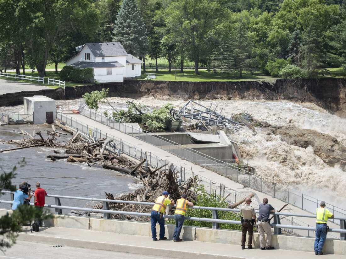
Onlookers take in the catastrophic damage to the Rapidan Dam site in Rapidan, Minn., on Monday. Debris blocked the dam, forcing the heavily backed up waters of the Blue Earth River to reroute along the bank nearest the Dam Store.
Casey Ek/The Free Press/AP
hide caption
toggle caption
Casey Ek/The Free Press/AP
The sheriff’s office in Monona County, near the Nebraska border, said the Little Sioux River breached levees in several areas. In neighboring Woodbury County, the sheriff’s office posted drone video on Facebook showing the river overflowing the levee and flooding land in rural Smithland. No injuries were immediately reported.
Patrick Prorok, emergency management coordinator in Monona County, described waking people at about 4 a.m. in Rodney, a town of about 45 people, to recommend evacuation. Later Tuesday morning, the water hadn’t yet washed into the community.
“People up the hill are saying it is coming our way,” Prorok said.
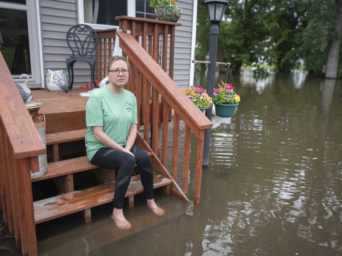
Rachel Morsching sits Tuesday on the flooded porch of her father Dean Roemhildt’s home in Waterville., Minn. Waters from the nearby Tetonka and Sakatah lakes have encroached on the town amid recent heavy rains.
Casey Ek/The Free Press/AP
hide caption
toggle caption
Casey Ek/The Free Press/AP
As new areas were flooding Tuesday, some cities and towns were cleaning up after the waters receded while others downstream were piling sandbags and taking other measures to protect against the oncoming swelled currents. Some normal, unassuming tributaries ballooned into rushing rivers, damaging homes, buildings and bridges.
“Normally, this river is barely a trickle,” 71-year-old Hank Howley said as she watched the Big Sioux’s waters gush over a broken and partially sunken rail bridge in North Sioux City, South Dakota, on Monday. “Really, you could just walk across it most days.”
South Dakota state geologist Tim Cowman said that the five major rivers in the state’s southeastern corner have crested and are dropping, albeit slowly. The last of those rivers to crest, the James, did so early Tuesday.
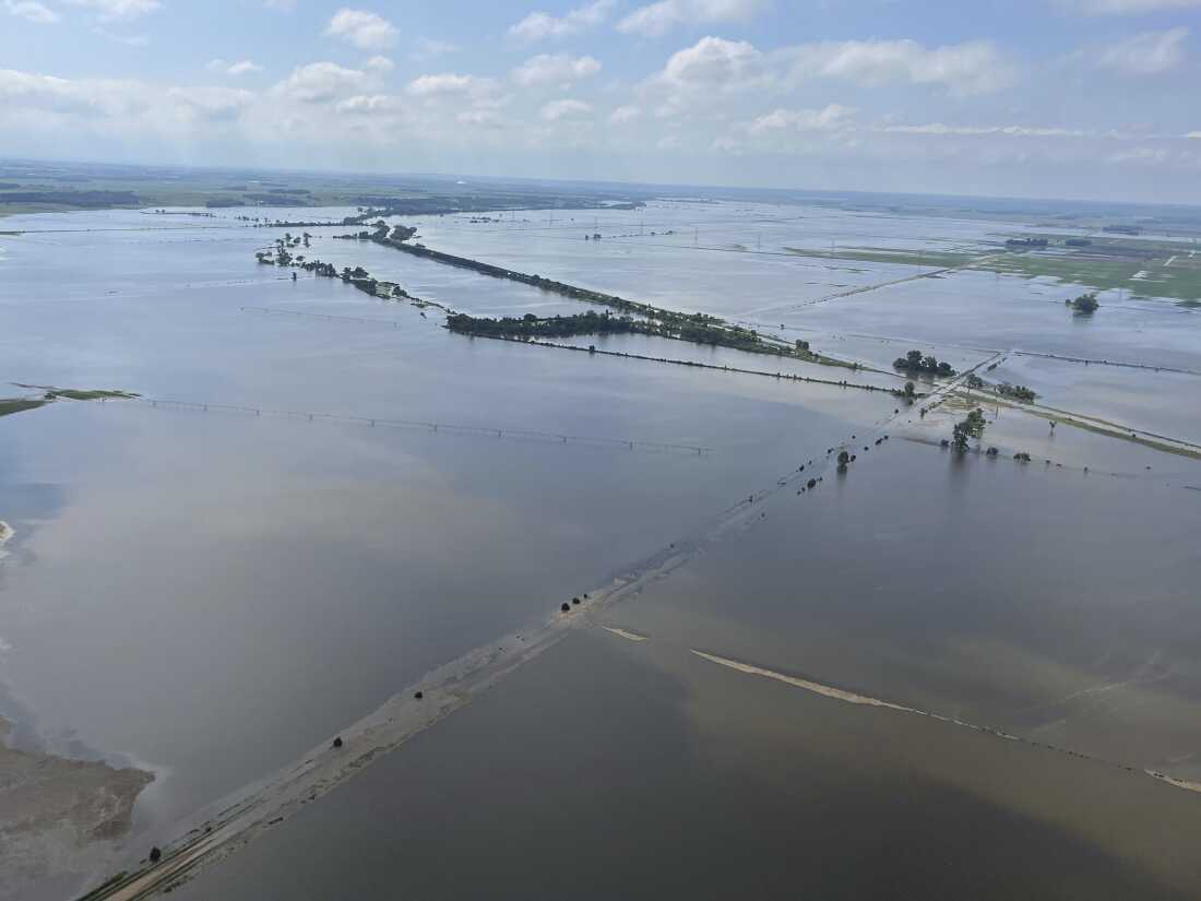
Heavy rains in recent days have submerged farmland near Vermillion, S.D., on Tuesday. Flooding has devastated communities in several states across the Midwest.
Jake Hoffner/AP
hide caption
toggle caption
Jake Hoffner/AP
In a residential development along McCook Lake in North Sioux City, the devastation became clear Tuesday as floodwaters began to recede from Monday, exposing collapsed streets, utility poles and trees. Some homes had been washed off their foundations.
“Currently, there is no water, sewer, gas or electrical service in this area,” Union County Emergency Management said in a Facebook post.
President Biden approved a major disaster declaration for affected counties in Iowa on Monday, a move that paves the way for federal aid to be granted.
To the south in Sioux City and Woodbury County, Iowa, officials responded to residents’ complaints that they had received little warning of the flooding and its severity. Sioux City Fire Marshal Mark Aesoph said at a news conference Tuesday that rivers crested higher than predicted.
“Even if we would have known about this two weeks ago, there was nothing we could do at this point. We cannot extend the entire length of our levee,” Aesoph said. “It’s impossible.”
Water had spilled over the Big Sioux River levee, and Aesoph estimated hundreds of homes likely have some internal water damage.
Homes on the south side of Spencer, Iowa, near the Little Sioux River are unlivable as water has reached the main floor, resident Ben Thomas said. A lot of people in town are facing a “double whammy,” with homes and businesses affected.
Officials in Woodbury County said around a dozen bridges over the Little Sioux River had been topped by flood water, and each would need to be inspected to see if they can reopen to traffic.
Forever Wildlife Lodge and Clinic, a nonprofit animal rescue, in northwest Iowa has answered over 200 calls since the flooding started, said licensed wildlife rehabilitator Amanda Hase.
Hase described the flooding as “catastrophic” for Iowa wildlife, which are getting washed out of dens, injured by debris and separated from each other. She and other rehabilitators are responding to calls about all kinds of species, from fawns and groundhogs to bunnies and eaglets.
“I’ve never seen it this bad before, ever,” she said.
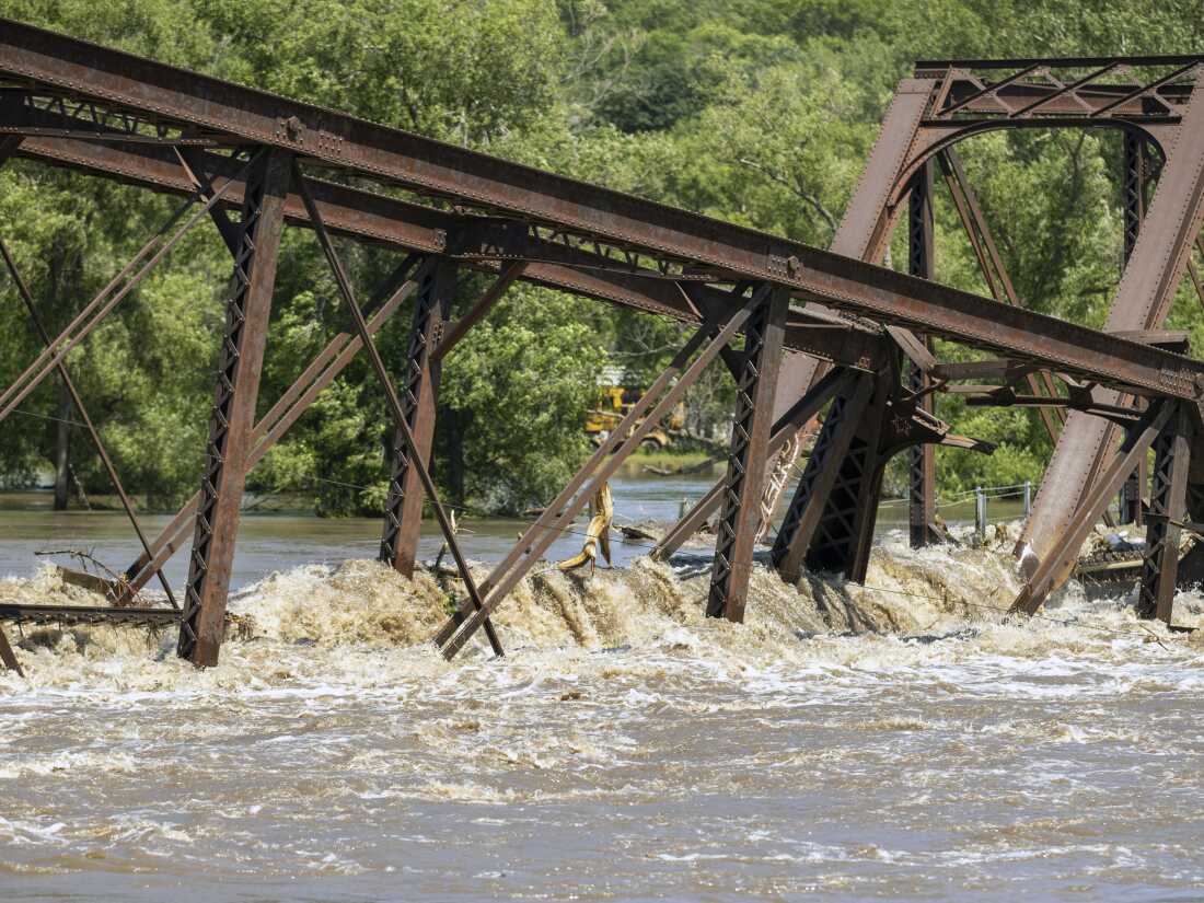
Floodwaters rush over a collapsed railroad bridge over the Big Sioux River near North Sioux City, S.D., on Monday.
Josh Jurgens/AP
hide caption
toggle caption
Josh Jurgens/AP
Further to the east in Humboldt, Iowa, a record crest of 16.5 feet was expected Wednesday at the west fork of the Des Moines River. Amid high temperatures and humidity, nearly 68,000 sandbags have been laid, according to county emergency manager Kyle Bissell.
Bissell told reporters Tuesday that there was no water on the streets yet, but flooding had begun in some backyards and was reaching up to foundations. Humboldt is home to nearly 5,000 residents.
More severe weather was forecast to move into the region Tuesday, potentially bringing large hail, damaging winds and even a brief tornado or two in parts of western Iowa and eastern Nebraska, according to the National Weather Service. Showers and storms were also possible in parts of South Dakota and Minnesota, the agency said.
In Michigan, more than 150,000 homes and businesses were without power Tuesday morning after severe thunderstorms barreled through, less than a week after storms left thousands in the dark for days in suburban Detroit.
The weather service also predicted more than two dozen points of major flooding in southern Minnesota, eastern South Dakota and northern Iowa, and flood warnings are expected to continue into the week.
Many streams, especially with additional rainfall, may not crest until later this week as the floodwaters slowly drain down a web of rivers to the Missouri and Mississippi. The Missouri will crest at Omaha on Thursday, said Kevin Low, a weather service hydrologist.
North of Des Moines, Iowa, the lake above the Saylorville Dam was absorbing river surge and expected to largely protect the metro area from flooding, according to the Polk County Emergency Management Agency. The U.S. Army Corps of Engineers projected Tuesday that water levels at Saylorville Lake will rise by more than 30 feet by the Fourth of July.
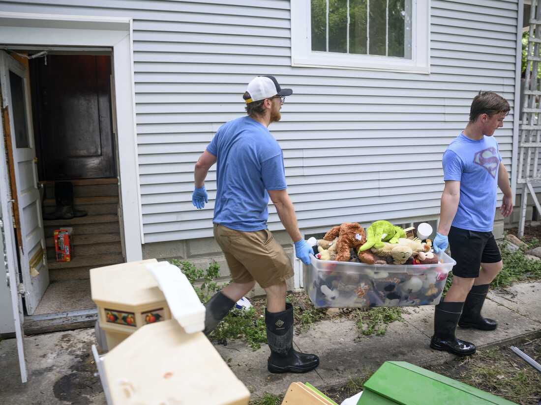
Jared Gerlock (left) and his son, Robbie, carry a bin of water-logged stuffed animals out of the flood-damaged basement of their home on East Second Street in Spencer, Iowa, on Tuesday. Officials said about 40% of properties in the city were affected after the Little Sioux River flooded.
Tim Hynds/Sioux City Journal/AP
hide caption
toggle caption
Tim Hynds/Sioux City Journal/AP
Outside Mankato, Minnesota, the local sheriff’s office said Monday that there was a “partial failure” of the western support structure for the Rapidan Dam on the Blue Earth River after the dam became plugged with debris. Flowing water eroded the western bank, rushed around the dam and washed out an electrical substation, causing about 600 power outages.
Eric Weller, emergency management director for the Blue Earth County sheriff, said the bank would likely erode more, but he didn’t expect the concrete dam itself to fail. The two homes downstream were evacuated.
Minnesota Gov. Tim Walz on Tuesday cautioned against rebuilding too fast, instead emphasizing more sustainable repairs that could prevent or mitigate future flooding.
“Nature doesn’t care whether you believe in climate change or not,” Walz said. “The insurance companies sure believe in it. The actuarials sure believe in it, and we do.”

